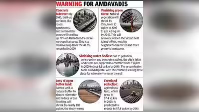

Ahmedabad: Imagine a city where nearly eight out of every ten steps you take are on concrete, asphalt. They may be little grass, and very few trees left. That could be Ahmedabad by 2045 if development continues unchecked. A new study has predicted that by the year 2045, Ahmedabad’s “artificial concrete footprint” will expand to cover a massive 77.1% of the metropolitan region, which includes areas under Ahmedabad Municipal Corporation (AMC), Auda and small portions of Guda and Gandhinagar Municipal Corporation (GMC).Unchecked urban sprawl could take the built-up area to 310.2 sq km. At the same time, the city’s green cover is on the verge of steep decline. The research predicts that vegetation cover, the city’s green lungs, will shrink massively from 33.04 sq km of the metropolitan region in 2000 to a mere 5 sq km by 2045, a worrying 85% decline. This means Amdavadis could be left with little tree cover to escape harsh heatwaves.This warning comes from a new satellite data-based study titled, “Integrating GEE, Machine Learning, and MOLUSCE for Predicting Urban LULC Dynamics of Ahmedabad Metropolitan Region, India” by Rupesh Gupta, of the Delhi University’s department of continuing education and extension. The study has been published in the International Journal of Engineering and Geosciences.The city is already feeling the impact. Gupta states, “This 85% loss of natural vegetation over 45 years would severely undermine the city’s ecological resilience, affecting carbon sequestration, microclimate regulation, air quality, and biodiversity.” He states that major development projects like the Delhi-Mumbai Industrial Corridor (DMIC), smart city initiatives, and the rapid expansion of metro and expressway networks are catalysing a heavily lopsided urbanisation. The study’s analysis reveals that “between 2000 and 2020, our built-up concrete area expanded by 62 sq km, growing from 161.4 sq km to 223.4 sq km. Almost all of this new concrete was poured over what used to be open barren land, which shrank from 125.7 sq km to just 50.8 sq km.Gupta explains, “Barren land, a category often acting as a spatial buffer or development reserve, will decline sharply. This indicates that nearly all open and underutilized land within the metropolitan boundary will be converted to constructed or semi-constructed surfaces”, which could “significantly worsen surface runoff and waterlogging and reduce long-term flexibility in urban planning”. To prevent this, he urges the immediate creation of a metropolitan land use observatory to track changes in real-time, with strict laws to protect wetlands, boost urban forests and mandate rooftop gardens.Gupta used Google Earth Engine (GEE), cloud computing platform, to process decades of satellite pictures. He selected imagery from the USGS Landsat 7 satellite for the year 2000 and the Landsat 8 satellite for 2020 and fed the images into an AI-based special simulator called the Cellular Automata–Artificial Neural Network. While farming land in the peri-urban areas of Ahmedabad grew slightly between 2000 and 2020 due to better irrigation, the AI model predicts that by 2045, cropland is projected to reduce from 97.4 sq km down to just 57.4 sq km.