









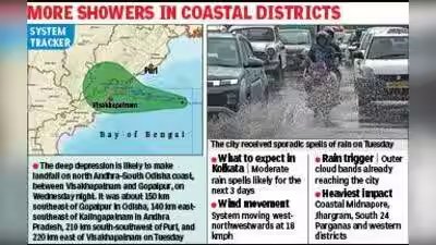
Kolkata: The city might not be in the path of the weather system that is building up over the Bay of Bengal but peripheral clouds from the depression have already started bringing rain to Kolkata and other parts of the state. While the Met office has allayed fears of the system intensifying into a cyclonic storm, Kolkata is likely to get spells of moderate rain for the next three days.The system is likely to hit land as a deep depression and not a cyclone.What started off as a low-pressure area over the west-central and adjoining east-central Bay of Bengal intensified into a depression by Monday evening. According to a special IMD bulletin, it was moving at a speed of 18 kmph on Tuesday. It was about 200 km southeast of Gopalpur in Odisha, 200 km east-southeast of Kalingapatnam in Andhra Pradesh, 210 km south of Puri, and 290 km east of Visakhapatnam.As the system kept inching towards the land the cloud columns from the outer band of the system reached the city skies, triggering few spells of rain. While Alipore recorded around 11 mm of rain till Tuesday evening, the Met office says more rain in store in the next few days.“We are issuing moderate rain for Kolkata as of now while the maximum impact is likely to be coastal districts of Midnapore, Jhargram and South 24 Parganas and western districts where heavy to very heavy rain is expected,” said HR Biswas, head at Regional Meteorological Centre Kolkata.Last year torrentiall rain, 251 mm of rain within 24 hours on September 23 left the city flooded during the Durga Puja festival. Despite the major weather system impacting parts of Bengal, Met office said the city is likely to escape with moderate rain.“This system is likely intensify further into a deep depression by tonight and continue to move west northwestwards and cross north Andhra Pradesh – South Odisha coasts between Visakhapatnam and Gopalpur as a Deep Depression by Wednesday night,” added Biswas.