









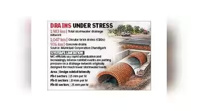
Chandigarh: A day after a portion of the carriageway near Transport Light Point on the busy Madhya Marg caved in following a heavy downpour, attention has once again turned to Chandigarh’s ageing underground circular brick drain (CBD) network, much of which dates back to the 1960s.The collapse of a section of the CBD passing beneath Madhya Marg in Sector 28 during Tuesday evening’s rain has raised concerns about the structural integrity of similar drainage infrastructure across the city.More than six decades after being laid, the CBD network now requires extensive repairs and major overhauling, particularly in vulnerable stretches, to ensure its long-term structural sustainability and improve its ability to carry larger volumes of stormwater generated during intense rainfall events.Officials cite multiple factors behind the need for strengthening the network. One of the key concerns is the repeated puncturing of CBD lines to lay optical fibre cables (OFCs) and other utility services over the past several years. In many parts of the city, telecom cables have been routed through these drains.“Several telecom operators punctured the CBD network while laying cables across the city. Though repairs are carried out after obtaining the necessary permissions, the process weakens the overall strength of the drains. Alternative ducts or dedicated utility corridors should be created for such services instead of allowing repeated puncturing of these decades-old structures,” MC officials said.Apart from damage caused by utility installations, officials point to the age of the infrastructure and growing stormwater runoff as major challenges.“The existing drainage system is increasingly becoming inadequate during heavy rainfall because of its original design capacity and the rise in stormwater discharge. When these drains were planned in the 1950s and 1960s, only a limited number of northern sectors existed. Since then, the city has expanded significantly, especially in the southern sectors, resulting in much higher surface runoff,” sources said.Officials added that these design limitations often lead to temporary flooding in various parts of the city during intense rain events. Stormwater from different sectors is channelled into N-Choe and Sukhna Choe through various outfalls, depending on ground levels.