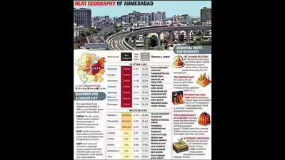
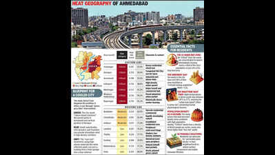
Ahmedabad: Heat exposure in Ahmedabad depends heavily on where you live. Eastern wards — crammed with residents, stripped of trees, and up to 8°C hotter than rural surroundings — are particularly vulnerable. Western areas are relatively cooler due to lower population density and better green cover. A new study by Pandit Deendayal Energy University (PDEU) puts numbers to this reality and ranks every ward based on a Relative Heat Risk (RHR) Index.Researchers Shubham Kela, associate professor Anurag Kandya, and Viral Patel created a Relative Heat Risk (RHR) Index used NASA satellite data to combine land surface temperature, green cover, and population density into a single score. The findings are stark: 16 eastern wards fall into the “critical” heat risk category. With an average density of 58,415 people per sq km and minimal tree cover, these wards house 32.4% of the city’s population. Six additional “severe” risk wards push that figure to 44%, meaning nearly half the city lives in “thermal danger”.The critical zone itself covers just 53.6 sq km, making it one of the most densely populated and heat-stressed urban pockets in the country.Viratnagar tops the danger index (0.767), followed by Dariapur (0.753), Amraiwadi (0.748), Indrapuri (0.736), and Maninagar (0.717), all in the east. Conversely, lower-risk wards include Gota (0.153), Maktampura (0.176), and Sarkhej (0.208), mostly in the west.Even “better” areas struggle. Gota, the greenest ward, has 68% of its land below the minimum vegetation threshold for urban areas, defined in the study as a Normalized Difference Vegetation Index (NDVI) of 0.3. In 10 wards, over 95% of land falls below this baseline.Prof Kandya said, “Heat is a city-wide issue, but targeted action is necessary.” He explained, “The study prioritizes land surface temperature over ambient as it is easier and cheaper to measure across large areas, making it a practical tool for resource-limited administrations.”By identifying the most vulnerable pockets, the index offers a clear starting point for municipal interventions. As Kandya put it, the data allows officials to identify vulnerable pockers and offers a clear starting point for municipal interventions.