










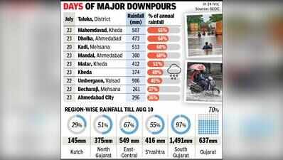
Ahmedabad: Amdavadis will remember July 23 as a day when heavy rain lashed the city, leaving several areas inundated. It brought disruption and chaos as many societies remained waterlogged, schools and colleges declared a holiday and commuters were caught in long jams. According to State Emergency Operations Centre (SEOC) data, the deluge of 296mm in 24 hours accounted for 36% of Ahmedabad’s average annual rainfall of 826 mm.Ahmedabad is not alone to have already received a good chunk of its annual rainfall. Over 15 talukas have recorded over 25% of their total seasonal rainfall in a matter of 24 hours.Some of the major rainfall events were recorded at Mehmdabad (Kheda) with 65% of seasonal rainfall in 24 hours, followed by 64% in Dholka (Ahmedabad) and 60% in Kadi (Mehsana) among others. In absolute terms, the highest single-day rainfall this season was recorded at Umbergaon (Valsad) on July 22 at 906mm, accounting for 45% of the taluka’s annual rainfall.An analysis of SEOC data for the 2026 monsoon shows that only 10 days of rain (July 20 to 26, July 28, Aug 1-2) accounted for 371mm, which is 58% of the 637mm rainfall recorded so far. Gujarat so far has received 70% of the annual average rainfall, according to SEOC.A 2025 study by a group of researchers from Vishwakarma Government Engineering College analysed rainfall patterns from 1990 to 2022. Their findings read, ‘Despite the overall increase in rainfall, the number of rainy days has declined, leading to fewer but more intense precipitation events. This has resulted in a simultaneous rise in the frequency of both floods and droughts, as well as “green drought” events.’ The study concludes that Gujarat’s rainfall patterns have shifted towards greater intensity and unpredictability, posing significant challenges to water management, agriculture and urban infrastructure.Other research published earlier this year with researchers from Indian Institute of Tropical Meteorology (IITM) and other institutions also pointed to ‘increase in the frequency of extreme events over western India during 1970–2022.’ The first pattern is marked by a large-scale mid-level cyclonic vortex spanning the subcontinent and strong easterly anomalies over the Equatorial Indian Ocean (EIO). The second pattern, according to the study, is of a localised cyclonic vortex centred over western India, featured by an isolated synoptic low-pressure system.