










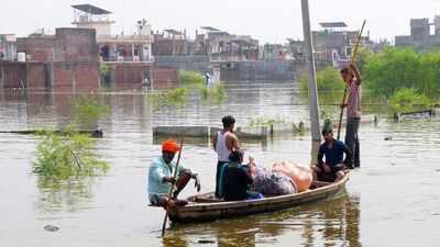
LUCKNOW: After keeping several low lying parts of Lucknow inundated for nearly two weeks, the Gomti river is expected to begin receding later on Wednesday as water levels at key upstream gauge stations have started falling, indicating that the flood wave generated by exceptionally heavy rainfall across the upper catchment has almost crossed the state capital.Although the river continued to rise marginally in Lucknow on Wednesday morning, irrigation department officials said the increase was the result of delayed upstream runoff rather than fresh rainfall.At 10 am on Wednesday, the Central Water Commission recorded the Gomti at 107.20 metres at Hanuman Setu, slightly higher than 107.18 metres at 8 am. The river, however, remained well below the warning level of 108.50 metres, danger mark of 109.50 metres, and the highest flood level of 110.85 metres recorded on September 10, 1971.The trend upstream, however, has already reversed. At Neemsar gauge, around 90 km upstream of Lucknow, the river level declined from 121.90 metres on Tuesday to 121.76 metres on Wednesday. The gauge is right before Kathina tributary of Gomti.At Bhatpurvaghat, about 40 km upstream and located before the Sarayan river joins the Gomti, the level fell from 113.14 metres to 113.11 metres.In contrast, Lucknow recorded a marginal increase from 107.08 metres on Tuesday to 107.18 metres on Wednesday morning, reflecting the time lag between upstream flows and their arrival in the city.Officials said water released from the upper basin typically takes several hours, and at times nearly a day, to influence river levels in Lucknow. With upstream inflows now weakening, the Gomti is expected to stabilise before beginning a gradual recession later on Wednesday, provided there is no fresh spell of heavy rainfall across the catchment.The present flood is the outcome of a hydrological process that began nearly two weeks ago. Originating at Gomat Taal in Pilibhit, the Gomti flows through Shahjahanpur, Lakhimpur Kheri, Hardoi and Sitapur before reaching Lucknow. It then passes through Barabanki, Ayodhya, Sultanpur, Jaunpur and Ghazipur before joining the Ganga. According to irrigation department officials, the river travels at an average speed of around 30 km a day, taking eight to ten days for runoff generated in the upper catchment to reach Lucknow.That explains why the river continued to rise in the city even several days after rainfall had stopped.Rainfall between Sept 25 and 27 illustrates the magnitude of the event. Lakhimpur Kheri received 268.3 mm against a normal of 7.3 mm, Shahjahanpur 263.9 mm against 5.3 mm, Hardoi 147.2 mm against 4.1 mm, Sitapur 144.1 mm against 7.5 mm, and Pilibhit 119.9 mm against 8.6 mm. Lucknow itself recorded 180.5 mm during the three day spell, compared with a normal of 9.4 mm.Hydrologists said it is the cumulative rainfall across the entire basin, rather than rainfall over Lucknow alone, that determines the river’s behaviour in the city. As runoff from Pilibhit, Shahjahanpur, Lakhimpur Kheri, Hardoi and Sitapur moved downstream over several days, it continuously fed the Gomti. Before entering Lucknow, the river also receives additional inflows from tributaries such as the Kathina, Sarayan, Gon, Behta and Kukrail, further increasing its discharge.The gradual arrival of this flood pulse was reflected at the Hanuman Setu gauge, where the river level climbed steadily from 106.55 metres on Oct 2 to 106.63 metres on Oct 3, 106.80 metres on Oct 4, 106.94 metres on Oct 5, 107.08 metres on Oct 6, and 107.20 metres on Wednesday.Interestingly, the current flooding has occurred despite the Gomti carrying much less water than during its historic floods. Irrigation department officials estimate that the river is presently carrying around 40,000 cusecs, while the barrage has a design capacity of 1.25 lakh cusecs. During the record flood of 1971, when the river touched 110.85 metres, nearly 1.07 lakh cusecs passed through the barrage. In 1985, when the river reached the danger mark of 109.50 metres, the discharge was estimated at around 74,000 cusecs.Officials said this year’s inundation is therefore not the result of exceptionally high discharge alone. Encroachment of natural floodplains by residential colonies, prolonged upstream inflows, low lying settlements and inadequate drainage have together slowed the spread and recession of floodwaters.“We must also consider that numerous residential colonies and other structures have come up on the Gomti floodplain over the years. These obstructions restrict the river’s natural ability to spread across its floodplain during high flows, forcing water levels to rise higher within the channel. Under natural conditions, the river would disperse over the floodplain instead of remaining confined,” an irrigation department official said.Authorities expect the river to begin receding later on Wednesday. However, waterlogging in localities such as Faizullaganj, Daud Nagar, Ghaila and adjoining colonies is likely to persist for some time, as accumulated floodwater will continue draining back into the Gomti even after the river level starts falling.