










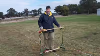
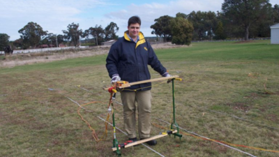
As a teenager, Dave Hunter built a rudimentary radar device to locate buried bulls on his grandfather’s farm. Decades later, that childhood experiment has evolved into a career helping communities find forgotten burial sites without disturbing the ground. His latest project has helped an outback council in Australia uncover 658 previously unmarked graves across two cemeteries in far-west New South Wales.Hunter, known as ‘Dave the Grave Hunter’, was contracted by the Central Darling Shire Council in July 2025 to investigate possible lost graves at the Menindee and White Cliffs cemeteries. Using specialist ground-penetrating radar equipment, his company, Hunter Geophysics, identified more than 300 burial sites at each location. A local report put the final tally at 338 graves at White Cliffs and 320 at Menindee. The project was completed in September 2026, according to the council.The discoveries were made without digging up the sites. Instead, Hunter pushed a machine resembling a lawn mower across the cemetery grounds, scanning the soil for signs of old burial pits. The findings have allowed the council to mark and protect places that had gradually disappeared from records or lost their visible markers.
From buried bulls to forgotten graves
Hunter’s interest in what lies beneath the ground began on his grandfather’s farm in Rushworth, northern Victoria. As a teenager, he was asked to locate bulls that had been buried on the property. With no sophisticated equipment at hand, he put together a basic device using a multimeter.That early experiment eventually grew into an interest in geophysics. Hunter later studied archaeology at La Trobe University and developed crude geophysical equipment to locate the remains of old buildings and gardens beneath a school in Melbourne. He went on to establish Hunter Geophysics in 2009, building a business around locating buried features and unmarked graves.He now completes around 10 to 15 cemetery projects a year, according to ABC News. His work involves using ground-penetrating radar (GPR), a technology that sends radar waves into the earth and records the signals reflected by changes in underground structures.However, the equipment does not actually detect human remains. Hunter told ABC News that it identifies the hole originally dug for a burial, rather than a body or skeletal remains. The disturbed soil left behind when a grave is filled can create a detectable contrast with the surrounding ground. In a cemetery, the dimensions and depth of such a disturbance can help him assess whether it is likely to be a grave. Hunter cautioned that the process is not an exact science and requires interpretation of the data.
Giving forgotten graves their place again
The discoveries in Menindee and White Cliffs are now helping the council preserve the cemeteries and work towards identifying the people buried there. Council cemetery officer Tammie McMaster has been speaking to residents and examining old records and archives in the hope of attaching names to the graves.The council has also considered extending the project to other communities in the region, including Wilcannia and Tilpa. The work is important not only for planning future burials but also for ensuring that existing graves are not accidentally disturbed.At White Cliffs, a large rock has been placed in the cemetery to accommodate memorial plaques. The newly identified sites can also be marked and protected, helping preserve the history of the people buried there.The challenge is not unique to the outback. Across Australia, old cemetery records have been lost, wooden headstones have deteriorated and burial locations have faded from community memory. Research by archaeologists has highlighted how ground-penetrating radar can help locate such sites without invasive excavation and Hunter has been able to help with that.