









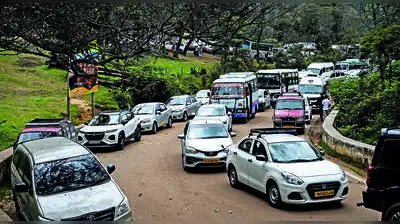
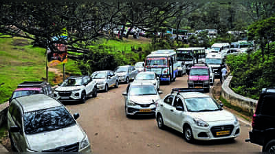
Experience a 50km trek through the forests of Kodaikanal. But encounter its 5km traffic snarls too. Unwind in the coffee plantations of Yercaud. But get wound up in its parking crunch too. Tourism might be the lifeblood of Tamil Nadu’s hill towns, but it is also stretching them to their limits.Now, there’s a new ‘Hill Area Master Plan’ in the offing that aims to set things right. Better roads, parking, waste management and safer hill slopes could soon become a reality for residents and tourists in Tamil Nadu’s seven major hill towns, with the govt sanctioning `10.71 crore to prepare climate-resilient master plans for ecologically fragile regions.The housing and urban development department has accorded administrative and financial sanction for the plans covering 1,200sqkm across Udhagamandalam, Coonoor-Kotagiri, Gudalur, Nelliyalam, Kodaikanal, Valparai and Yercaud. Udhagamandalam and Valparai, covered under the AMRUT 2.0 sub-scheme for hill area towns, have been integrated into the master plan.“Let’s hope for the best, says N Balamurugan, former member of a local body vending committee. “Fridays are the worst in Kodaikanal. That is when the influx of traffic begins. We have traffic snarls that stretch up to 5km. As there is no parking facility, vehicles clog the roads.” Roads in most hill stations are only 15ft-20ft wide, narrowing to just 12ft near Silver Cascade in Kodaikanal. “When heavy vehicles pass, traffic worsens,” he says.The master plan, says an official, hopes to ease congestion, with construction of an Outer Ring Road via Naidupuram and Pallangi.The plans are also expected to guide future development while safeguarding forests, water bodies and landslide-prone areas from unplanned urbanisation. They will also integrate climate resilience, disaster preparedness and tourism infrastructure to make hill settlements safer and more sustainable.The blueprint is part of the state’s 2025-2026 budget announcement to prepare dedicated master plans for seven hill towns, recognising that conventional urban planning is inadequate for environmentally sensitive regions with difficult terrain.But, say officials, unlike regular master plans, consultants will undertake detailed studies on topography, geotechnical conditions, forests, water channels, tourism facilities, tribal habitations and landslide-prone areas before finalising proposals. “We will use GIS-based mapping backed by drone surveys to prepare high-resolution maps and identify environmentally sensitive zones with greater accuracy,” says the official.S Babjee, an urban planner at Vagamon Botanical Garden, says the first step is to study the geological aspect of hill stations to prevent landslides. “The hydrological outlines, fault lines and endemic species also need to be studied,” says Babjee.“The state should adopt a hill station policy that caps tourist numbers. At this point in time, anyone can open a stall or a shop. It needs to be licensed better,” he says.S Srivalli, a chocolate vendor in Yercaud, says the govt also needs to prepare a livelihood development plan, which identifies local occupations and integrates them with tourism. “At present, many vendors occupy public spaces around tourist spots without licences or vending regulations,” she says.Environment secretary Supriya Sahu says the directorate of town and country planning has been asked to begin work immediately. “Plans would enable projects on solid waste management, environmental protection and wildlife conservation. They will factor in tourism and trek opportunities too,” she says.As for the Nilgiris, the plan involves regularisation of tourism accommodations. Around 920 show-cause notices have been issued to home stays, bed and breakfasts and hotels in the Nilgiris so far, and 76 have been sealed.“Similar action will be taken in other tourism hotspots too. The drone survey will provide realistic data on illegal houses,” says an official. “Detailed project reports will be prepared soon,” says housing secretary Kirlosh Kumar.What’s the problem?Poor solid waste management; people dump waste along roadsides or throw it downhill; no system to collect and transport wasteUnregularised tourist accommodationInadequate urban planningWhat’s the plan?The combined planning area spans 1,200sqkm, with Kodaikanal accounting for the largest share at 488sqkm, followed by Valparai at 217sqkm, Udhagamandalam at 160sqkm, Coonoor-Kotagiri at 129sqkm), Nelliyalam at 94sqkm, Yercaud 62sqkm and Gudalur at 47sqkm.What’s the cost?Planning costs have been fixed based on the scope of work. GIS-based master plans for Coonoor-Kotagiri, Gudalur and Nelliyalam have been estimated at Rs 70,000 per sqkm, while Udhagamandalam and Valparai, where drone-based geo-database creation is included, have been estimated at Rs 88,000 per sqkm